


Lillooet River Corridor Engineering Study

Project Highlights
The Pemberton Valley, one of the fastest growing regions in Canada, is subject to regular flooding. This is caused, in part, by several large tributaries that discharge into the Lillooet River near Pemberton, British Columbia.
Objectives
Kerr Wood Leidal (KWL) was retained to provide a long-term management plan for the Lillooet River. Work included assessing existing geomorphic and hydrologic conditions, and updating the flood profile.
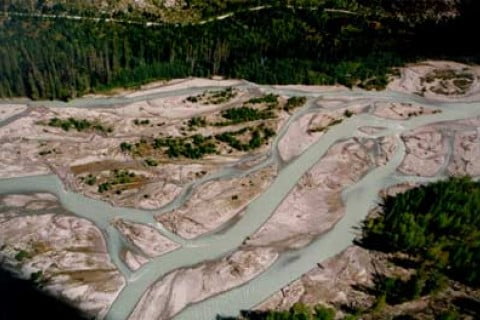
Assessing the River’s Geomorphology
In the late 1940s, extensive engineering works were implemented to reclaim agricultural land and prevent floods. KWL assessed the impacts of these drastic changes on the morphology and present alignment of the river. Much of the analysis was based on channel maps created by KWL from historical air photographs and existing cross-section survey data.
KWL also determined how much gravel is transported into the lower reaches of the river annually. This is critical in designing flood protection works because sediment accumulations tend to compromise the level of flood protection provided by dykes.
Identifying Areas at Risk
Water levels for a 200-year return flood were determined using Mike 11, an hydraulic model well suited to the complex hydrology of the river. Over 100 cross-sections were surveyed and input into the model. Modelling results identified areas where existing dykes were too low and areas requiring flood protection.
Reducing the Flood Risk
Using its hydraulic and geomorphic analysis, KWL is developing a river management plan for the Pemberton Valley. The plan will identify areas in need of flood protection and rank proposed works according to input from the local community, the Mount Currie Band, the Pemberton Valley Dyking District, and government officials.
KWL is also completing a gravel management plan to identify the volumes, location, and timing for gravel removals. The plan will prevent the channel bed from rising, reduce the flood risk, and help maintain the ecological character of the river.
Related Projects

Calgary Riparian Monitoring Program
Water Resources

Britannia Creek Debris Flood Mitigation
Water Resources

Inglewood Bird Sanctuary Reconnection Project
Water Resources

Highway 8 Hydrotechnical Emergency Response
Water Resources
Calgary Riparian Monitoring Program
Water Resources
Britannia Creek Debris Flood Mitigation
Water Resources
Inglewood Bird Sanctuary Reconnection Project
Water Resources
Highway 8 Hydrotechnical Emergency Response
Water Resources